Ketley Canal and the first Inclined Plane in the World
At the centre of the Ketley Paddock Mound LNR is the long pool, part of what was once the Ketley Canal, which was constructed between 1787 and 1788 by William Reynolds and his father Richard Reynolds of Ketley.
Reynolds and his father started work on the Ketley Canal in 1787, in order to transport ironstone and coal from Oakengates to their foundries at Ketley. It ran in a westerly direction from Oakengates, passing through a tunnel under Shepherds Lane, Potters Bank, and ended to the south of Ketley Hall. At this point there was a 73-foot drop to his Ketley Iron Works. You can find out more about the industrial history of Ketley on the Historicketley website.
Ketley Hall, with pleasure grounds and Canal in 1794
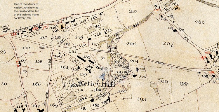
1794 Map of the Manor of Ketley – this shows the section of the Ketley Canal, running through a tunnel under Shepherds Lane, then curving past the rear of Ketley Hall, to the top of the Inclined Plane. Courtesy of Shropshire Archive, ref: 972/7/1/38. Paddock Mound now covers the plots no.206, 207, part of the canal marked 211 and 212
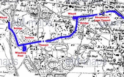
The canal is picked out in blue on an old Ordnance Survey map. The wharf area is now built on, but that end of the remaining canal forms a rich wetland area. The earliest Ordnance Survey Drawing was surveyed in 1814, and can be viewed here It is possible to view the full length of the canal while it was still operational and just a few years before Thomas Telford built the Holyhead Road.
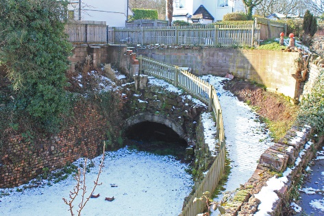
Although the incline was disused by 1818, after closure of the Ketley ironworks, the Ketley Canal still served a coal wharf near Ketley Hall in 1842, and was not finally abandoned until the 1880s. Little is left of the canal today, the basin can still be seen at the back of Ketley Hall and part of the canal on the Paddock Mound.
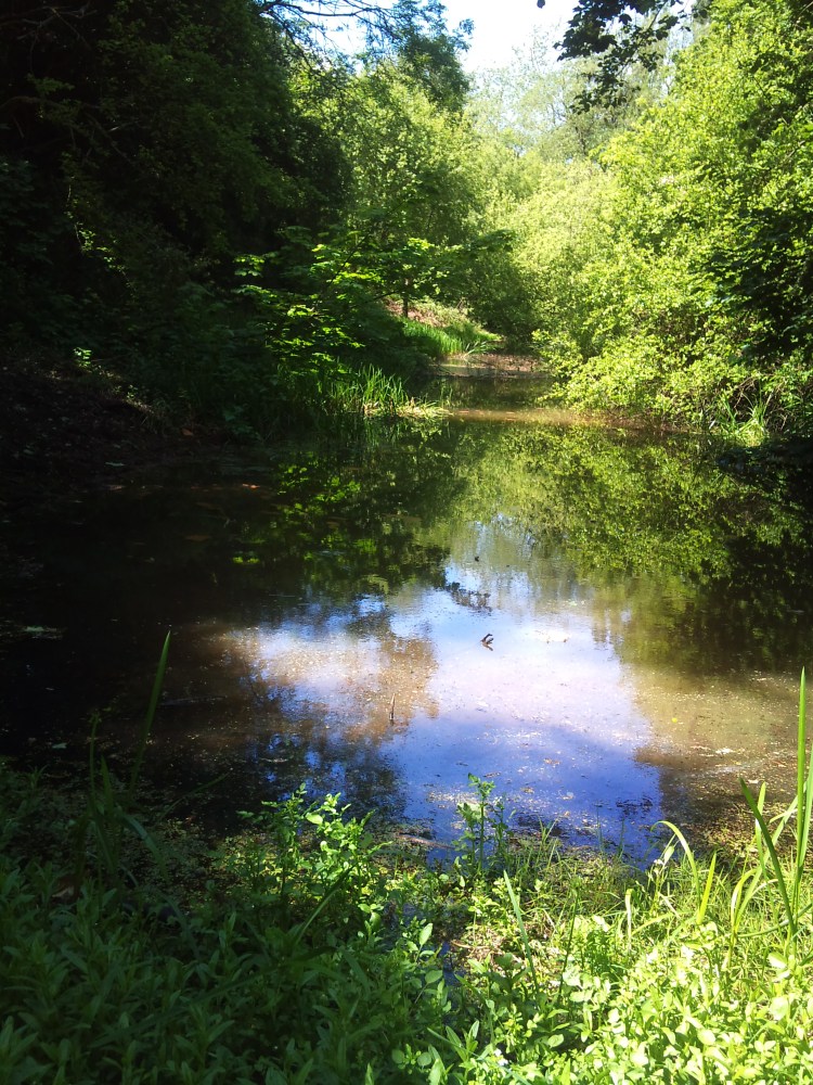
The last remnant of the upper section of the Ketley Canal in water – now a haven of wildlife and a peaceful, much loved spot.
William Reynolds
William Reynolds was born in 1758 at Bank House, Coalpit Bank (now called Ketley Bank) the son of the Ironmaster and Philanthropist Richard Reynolds. They moved to Ketley Hall about 1793 or soon after. Reynolds and his father started work on the Ketley Canal in 1787, in order to transport ironstone and coal from Oakengates to their foundries at Ketley.
The Ketley Canal
This ran from the Shrewsbury Canal at Oakengates to Ketley Iron Works, once the fifth largest ironworks in Britain. The canal was started in 1787 and ran under a tunnel and across Red Lake Hill – also known as the Welsh Hills. The canal curved around Ketley Hall, owned by William Reynolds.
From Ketley Hall, there was a drop of 73 feet to the iron works below. To build locks to lower the level of the canal was out of the question, as the meagre water supply for the canal was pumped from the mines. The main supply was probably the ‘Derbyshire’ level, an underground drainage channel which ran from Ketley to Old Park. It is said that slide rails were installed along the canal at some of the bends, which enabled a train of tub boats to be guided around the bends when pulled by a single horse. William Reynolds was an innovative ironmaster and he constructed an inclined Plane to take the tub boats with their loads of coal and Ironstone to the iron works below. A working model of the inclined plane was created by Alan Tidy.
An incined plane had been unsuccessfully devised in Ireland, but the Ketley Inclined Plane was the first successful working system in the world. A cradle carried each loaded tub boat and up to 30 laden boats a day were transported down to the ironworks. There is a detailed description of the Inclined Plane and the innovation of William Reynolds, written in 1813 when it was working at its capacity. The General View of the Agriculture of Shropshire by Joseph Plymley. Pages 290-300 cover the inclined plane, and following pages describe the Telford Aqueduct – the first made in Iron, which was made at the Ketley Ironworks. Norman Pagett has also created a web page explaining the whole setting of the inclined plane in the Ketley Canal.
The top section of the canal ended where it curved behind Ketley Hall, beside which the aparatus controlling the top of the inclined plane stood. Although little more is left of the canal today, the basin can still be seen at the back of Ketley Hall. This is now very overgrown, but below the undergrowth it is possible to see the stone laid walls forming the original structure of the canal. There are other pools – remnants of the canal near the foot of the hill, where the tub boats completed their journey to the iron works – now Saint Gobain.

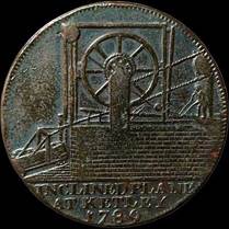
Ketley Token, showing the Inclined Plane and dated 1789. The token was issued in 1792 by Reynolds of Coalbrookdale, and the obverse shows the Ironbridge, erected in 1779. It was made of copper, and its value was 1/2 penny. It was to be used in Ketley and Coalbrookdale, and would have been issued to workers of the Reynolds company – only to be used in their premises.
The canal tunnel under Shepherds Lane – it is still visible on the eastern end, in a private garden
Maps of Paddock Mound – showing the canal, Landscape and positions of pit shafts
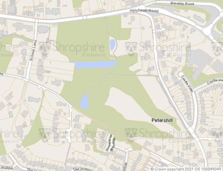


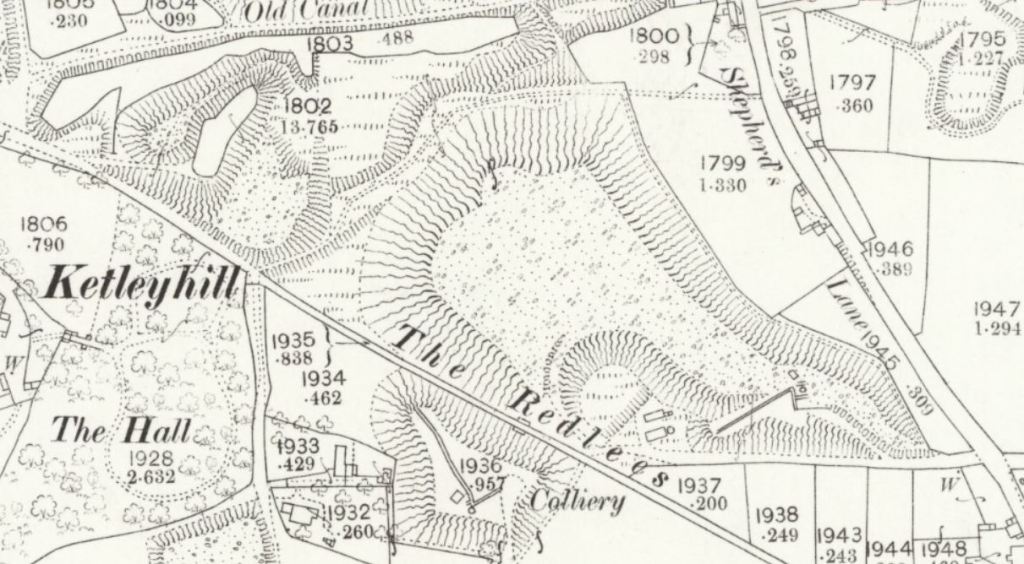
This section of the 1880 map shows the workings on the first rise of the mound – the old mineshaft which was capped in 1992 – it looks as though there are associated works below in the Glade – also there’s a shaft cross Red Lees, and you can just see the stone buttresses (below the letter R on the Redlees) perhaps a tramway once linked the two works?
There’s more information on the tramways on the Historic Ketley website https://historicketley.wordpress.com/ketley-wagonways-tramways/

.jpg)